Kawerau Geothermal Field.
Location and General Description
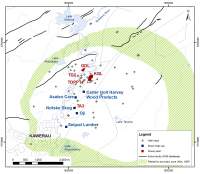
The Kawerau geothermal field is located in the Bay of Plenty Region, and sits in both the Kawerau and Whakatane districts. The system covers an area of about 35km2 and is bisected by Tarawera River.
Characteristics of the Kawerau system. The reservoir is liquid dominated with downhole temperatures ranging from 250 to 310°C. Estimates of the total available resource are between the equivalent of 350 MW(e) and 570 MW(e).
Several different companies draw on the Kawerau geothermal resource for both Geothermal industrial use direct heat use and electricity production. Four major consent holders includes Mercury NZ Limited, Ngāti Tūwharetoa Geothermal Assets Limited, Geothermal Developments Ltd, and Te Ahi O Māui Partnership.
Figure 2: Putauaki dominates the Kawerau landscape. In the foreground are the pulp, paper and timber mills, power station TG2 and the Onepu lagoon
The Crown has acknowledged that Ngāti Tūwharetoa (Bay of Plenty) has particular cultural, spiritual, historical, and traditional association with, and use of, the geothermal energy and geothermal water located in the Kawerau geothermal system.
The Kawerau system is classified as a Development System1 in the Bay of Plenty Regional Policy Statement. The system has been supplying steam to pulp paper and timber mills since 1957 and is one of the world’s largest direct geothermal heat use at a single location.
Kawerau was the first industrial-scale producing field in New Zealand (the year before Wairakei was commissioned) and was the second largest producing geothermal field in New Zealand until the commissioning of Ohaaki power station in 1989.
Natural features: history of human use and effects
Surface features at Kawerau were modified by the 1886 Tarawera eruption, which blanketed the area in ash and mud. Further changes occurred in the early 20th century when drainage schemes caused down cutting of the Tarawera River and lowering of water tables.
Most of the geothermal surface features are believed to have been in a natural state of decline prior to development of the field in the 1950s. Large springs at Rotoitipaku and Umapokapoka (Onepu) recorded in 1903 were generally absent when energy development started in the 1950s. The decline in surface activity accelerated with industrial development and with increased demand for energy use.
Kawerau District Council operates public thermally heated pools in the township. There are also motel pools and the private Savage Whānau Pool, which is used for bathing (fed with separated water from the mill supply system).
Geothermal vegetation, made up of prostrate kanuka and mingimingi, is found in the Parimahana Scenic Reserve, Te Taukahiwi o Tirotirowhetu Scenic Reserve, and land to the north in the west of the field, north of Kawerau township.
Characteristics of the Kawerau system
The Kawerau geothermal system occupies a structural depression in which a thick sequence of volcanic lavas and volcaniclastics overlie (torlesse) basement greywacke.
Drillhole data defines the main borefield and the field boundary is inferred from resistivity surveys and gravity data. Resistivity data, combined with the inferred location of the main heat and mass outflow, is consistent with deeply-sourced thermal fluids flowing from the south (near Putauaki) towards the northern part of the field.
Reservoir And Wells
Drilling for energy development started in 1951 and 1952, with the DSIR (now GNS) drilling 24 core and temperature holes to up to 60m deep. Drilling for production started soon after with KA1 and KA2 being drilled by the Ministry of Works (now MB Century) in 1952. A further 10 wells were drilled through to 1957.
Early wells declined rapidly from cool inflows: extensive well work overs were carried out in the late 1950s and early 1960s to case wells deeper, with three more wells being drilled in 1956-57. Calcite deposition was a significant problem resolved by work overs. KA19 was drilled in 1971 and put on production in 1972. It is still supplying steam to the mills today.
Seventeen wells (including redrills) had been completed by the end of 1957 when Kawerau became the first production field in New Zealand. In the late 1950s, four of the wells were deepened following decline in field production and further drilling began in 1966 after continued field decline. The Crown had an active drilling program from the mid-1970s through to mid-1980s, aimed both at maintaining steam supply to the mill and investigating a major expansion for power generation or other process steam supplies. Earlier wells required frequent cleanouts of calcite scale, however, downhole antiscalant systems are now used. New wells have occasionally been drilled to maintain the steam supply.
The geothermal fluids originate from fractures in the mesozoic basement rocks, which are overlain by a sequence of layered volcanic lavas, welded ignimbrites, pyroclastic rocks and lacustrine sediments. The permeable zones are commonly hosted by pyroclastic and fractured lava (rhyolite or andesite) units and within the fractured and/or faulted basement greywacke.
The typical production well depth is between 950m and 2100m, while injection well depth varies from 300m to 3000m.
The reinjection strategy uses a mix of shallow infield reinjection and deep peripheral field reinjection to the north. However, some wastewater from the field is discharged into the Tarawera River after passing through a cooling channel, and current resource consents require ongoing efforts to reduce geothermal discharge.
Geothermal industrial use
The area is dominated by the large timber, pulp and paper industrial complex, which also includes several geothermal power stations.