Wairakei Geothermal System
Location and General Description
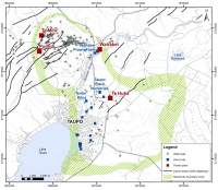
Wairakei Geothermal Field is New Zealand’s oldest and largest (by electrical generation). The field covers between 20 and 25Km2 and lies 8 km north of Taupo along State Highway 1. Pressure changes show that the Wairakei reservoir is partially connected to the adjacent Tauhara Field. By administrative convention, the Waikato River marks the boundary between Wairakei and Tauhara fields.
The Waikato Regional Plan classifies Wairakei as a Development Geothermal System where the take, use and discharge of geothermal energy and water are permitted subject to conditions.
Geology, Geophysics, and Drilling
Wairakei Field resides within volcanic strata of the Taupo Volcanic Zone. These rocks fill a Quaternary basin up to 3 km deep and comprise a stacked sequence of tuffs, volcanoclastics, and ignimbrites, with intrusive and extrusive igneous bodies. Most production comes from in the volcanogenic Wairoa Formation and its dacite-rhyolite dome equivalents.
The reservoir is capped by a hydrothermally altered (argillic) layer of Upper Quaternary lacustrine mudstones, breccias, ignimbrites, and tuffs. Propylitic alteration in the main reservoir increases with depth and is characterised by illite, chlorite, and epidote.
In the hydro dynamic zones, the reservoir has good vertical and surprisingly extensive horizontal permeability. The main upflow (265oC) resides along the western margin (Te Mihi area). This is supported by strong fluid recharge at the base of the system. Outflows move eastwards down the potentiometric gradient towards the Waikato River. Initially, both the Western and Eastern Borefields exploited this extensive outflow; currently only the Western Borefield remains productive.
Like other TVZ fields, Wairakei displays a marked shallow resistivity contrast between the shallow altered cap and surrounding, unaltered volcanics. This conductive layer is underlain by a zone of higher resistivity within the main reservoir. The central field is also de-magnetised.
Microseimic monitoring suggests the brittle-ductile transition and maximum depth of convection circulation is 6.5 to 8.5 km depth. Most events are shallow (< 4 km deep) and cluster within the field’s resistivity boundary.
Over 290 wells have been drilled in the field, including 148 production and injection wells. Currently there are 73 producing and 19 injection wells. Most of the early wells were shallow<1,000m; drilling has progressively probed deeper (to 3,012m) and laterally (to 1,994m) with time. The deepest feed is 2,880m. The hottest recorded temperature is 272oC at 1,100m. For the most part, the production wells tap a variety of fluid and steam feed zones ranging from 260oC to 209oC.
In response to 60 years of production, the total pressure drawdown in the main reservoir is 26 bar.g. Fluid temperatures in the outflow regions have declined 20oC. Shallow aquifer temperatures have declined up to 100oC.
Natural Features
Current surface features include steam heated ground (Craters of the Moon), thermal micro climates (Hall of Fame Stream, Te Rautehia Stream, Wairakei Stream, Waipouwerawera) and thermal surface waters (Alum lakes).
Prior to development, Wairakei contained geysers, hot springs, and sinter terraces scattered along “Geyser Valley.” Geoscientists estimate the pristine heat flow from the field totalled 430 MW(th). The surface does not display features indicating historic or pre-development hydrothermal eruptions.
The onset of steam/water production drew down ground water levels at Wairakei and curtailed the geysers and associated alkaline springs. Consequential reservoir boiling charged a vapour accumulation into two steam zones beneath the conductive cap as well as new thermal features including steaming ground, acidic pools and hydrothermal eruptions at Alum Lakes and Craters of the Moon, now a prominent feature along the southern margin of the field.
The pressure drawdown in the deep liquid reservoir propagated to shallow formations, triggering compaction within the clay-altered cap rock and inducing ground subsidence. Overall, ground subsidence is broad and difficult to detect with the eye. However, at one locality, cumulative subsidence from 60 years of operations has reclined the surface in excess of 15 metres within a circular structure or “bowl.”
Existing and Historical Geothermal uses
The Wairakei Power Station is the world’s second geothermal power station, and the first to utilise flash steam from geothermal water as an energy source.
The NZ Government, through the Department of Scientific and Industrial Research and Ministry of Works commenced exploratory drilling in the late 1940’s. By 1954, the Government had established a legal framework for exploitation of geothermal energy, purchased the Wairakei land, and solidified a commitment to build the first power station.
Construction of stages 1 and 1A (102 MW(e)) began in 1956 and finished in 1960. The first turbine generated power from Wairakei on 15 November of 1958. Stage 2 (90 MW(e)) finished commissioning in October 1963, bringing the total nameplate capacity to 191 MW(e).
In response to falling reservoir pressure, the field operator (NZ Electricity Department) de-commissioned two high inlet pressure units (G5 and G6) in 1982 and reduced the steamfield and plant capacity to 153 MW(e) net.
| Plant Name | COD | Units | OEM | Installed Net Capacity (MW(e)) | Avg. Annual Generation (GWh) |
|---|---|---|---|---|---|
| Wairakei A & B | 1958-60 | 2 x 6.5 MW; BPT 2 x 11.2 MW; BPT 1 x 11.0 MW; BPT 1 x 11.0 MW; CST-SF 1 x 11.0 MW; BPT 3 x 11.0 MW; CST-SF |
BHT** | 98 | 979 |
| 1963 | 3 x 30 MW CST-DF | AEI*** | 90 | ||
| 1996 | 1 x 4.5 MW; BPT | Parsons | 3.5 | ||
| Poihipi | 1996 | 1 x 50 MW; CST-SF | Fuji | 50 | 411 |
| Wairakei Binary | 2005 | Ormat | 14.4 | 83 | |
| Te Mihi | 2014 | Toshiba | 160 | 1,372 |
Notes
Notes
* units in red have been de-commissioned
* * British Thompson-Houston
*** Associated Electrical Industries (successor to BTH)
Following international fashion, the NZ Government re-structured the electricity market during in the late 1980s. The NZ Electricity Department was corporatized into the Electricity Corporation of NZ (ECNZ) in 1987. The Crown subsequently spun off the Wairakei assets into a separate entity, Contact Energy Ltd. in 1995.
Market de-regulation in NZ encouraged several independent geothermal power developments. These included the 50 MW(e) Poihipi power station commissioned on Wairakei’s south-western boundary by the Geotherm Joint Venture in 1996. The enterprise collapsed into insolvency due to a lack of steam and the assets were sold to Contact Energy in 2000. Poihipi initially utilised four wells tapping a thin steam zone created through boiling in the larger Wairakei reservoir. Contact Energy connected the station with the main Wairakei steamfield in 2006 and gradually brought the plant up to full capacity in 2011.
Contact improved the process conversion efficiency by replacing a pressure-reducing valve on the LP steam main with a refurbished BPT in 1996, and commissioning the 14.3 MW(e) Wairakei binary plant in June 2005. This “bottoming” plant captures and utilises the previously unused heat contained in 130oC, low-pressure flash, separated geothermal fluid.
Robust electricity growth in NZ kindled the next round of development. With the focal point of steam production shifting, Contact Energy re-configured the field to better utilise the resource. Accordingly, the capacity of the original A&B station was reduced to 130 MW(e) by decommissioning two turbines and installing two, 84 MW(e), Toshiba, dual flash, condensing steam turbines near the western boundary at Te Mihi in 2014. The new configuration raises the net field capacity to 360 MW(e).
In addition to the power stations, over the years the operator has configured Wairakei to provide direct heat to customers including the Tourist Park Hotel (1958), a prawn farm (1988), and tourist operator Wairakei Terraces (2002).
Wairakei provides consistent and reliable electricity. Annual power production from the initial A&B station remained remarkably steady for over 30 years. Over the 2018 financial year, the Field generated 2,770 GWh with an aggregate availability of over 95%.
Inferred size of resource
The current capacity of 352 MW(e) reflects an appropriate development relative to the reservoir size. No plans exist for expanding production in the future.