Tauhara Geothermal System
Location and general description
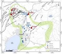
The Tauhara Geothermal Field lies along the eastern boundary of Taupō township (Waikato Region), at the northern end of Lake Taupō.
Based on resistivity surveys, the field covers between 18 to 35km2 and has pressure connections with the adjacent Wairakei Field. The boundary between the fields is ill defined and, for regulatory purposes, the border is taken as the Waikato River.
The Tauhara reservoir is liquid dominated with downhole temperatures ranging from 240oC to 290oC. The resource size is currently permitted at 250 MWe.
Contact Energy operates the field, generating electricity for the New Zealand power grid and supplying two phase fluid for industrial direct use. In addition, individual homeowners and businesses tap a shallow, hot-water reservoir for heating their homes and establishments.
The Waikato Regional Plan classifies the Wairakei-Tauhara Geothermal System as a Development Geothermal System where the take, use, and discharge of geothermal energy and water will be allowed, while remedying, mitigating, or avoiding significant adverse effects on the environment.
Before formal development, homes and hotels utilised surface/shallow geothermal heat and, in the 1950’s, The Spa Hotel even generated the first geothermal electricity in New Zealand. Larger scale production began in the 1970’s with the Crown supplying steam from well TH-2 to a native nursery for greenhouse heating. The field now hosts one power station (with two in construction) and two direct industrial users. When this construction is completed, Tauhara will comprise Aotearoa’s second largest geothermal electricity generation capacity with 250 MWe.
Natural features

Prior to the development at Wairakei Field, Tauhara contained liquid-fed springs at Spa Sights, Waipahihi-Terraces, and other areas around Mt Tauhara (Pony-Club, Broadlands, and Crown Road Reserves). Researchers estimate that the natural heat flow prior to exploitation was roughly 105 MWth.
Tauhara’s significant Geothermal Features include geothermally-influenced aquatic habitat (Onekeneke Stream), microclimates, hydrothermal eruption craters, hot springs, mud pools, steaming ground, and sinters.
Initial production at Wairakei caused pressures to drop in the uppermost Wairoa reservoir and induced boiling. This caused noticeable ground heating and steam flows. Other activity included three hydrothermal eruptions between 1970 and 1982.
Historical and existing geothermal uses
For centuries Māori used the Tauhara resource for heating, cooking, therapeutic healing, ritual ceremonies, and retain cultural associations with individual features; links to Mt. Tauhara go back to Ngātoro-i-rangi’s early exploration of the region.
Settlers first exploited the Tauhara geothermal resource by drilling domestic, shallow bores for heating, mostly around Taupō Town; some 50 bores were operating by 1950. Presently, there are over 400 shallow bores drawing geothermal fluid for domestic and commercial use.
Currently the resource has multiple users in the form of tourism, various pools, private bores, industrial direct heat, and power generation.
Development
The Crown drilled the first deep wells (TH-1 through 4) at Tauhara in the 1960’s. This campaign included drilling seven water-table and shallow acquirer monitoring wells. Subsequently, the Crown completed a pipe system to supply of geothermal fluid to the Taupō Native Nursery. The Crown sold most of its wells and rights to Contact Energy in the late 1990’s.
Contact Energy subsequently secured resource consents and commissioned the 20 MWth Tenon Heat Plant in 2006. This supplies 2-phase fluid to kilns at the Tenon Mill. Direct use applications continued with the commissioning of the 15 MWth Nature’s Flame heat plant in 2019. This facility supplies 2-phase fluid to the Nature’s Flame pellet plant. Together these two heat plants deliver 5 to 6 PJs of net energy annually. The heat supply to the pellet plant is enabling the replacement of coal at dairy plant boilers around the country.
Generation capacity also advanced with commissioning the Te Huka binary plant (24 MWe) in 2010; the two units were subsequently upgraded to 26 MWe in 2012 by expanding steam/fluid capacity.
Contact Energy holds permits (consents) that allow the current construction of two new power stations. Tauhara I, located in the Tauhara East Sector, will be a Fuji 174 MWe, triple flash, condensing steam turbine due for completion in 2024. Te Huka unit 3, located in the Tauhara Central Sector, is a 50 MWe Ormat binary plant scheduled for commercial operation in 2024.
Geoscience and Drilling
Tauhara Field resides at the eastern edge of the Taupō Volcanic Zone (TVZ) and comprises 3 to 4 km of Quaternary volcaniclastic fill. The eastern TVZ boundary comprises a series of NE trending normal faults dipping to the northwest with compensating sub-faults dipping eastwards.
Along this eastern TVZ fault zone, the Mesozoic Torlesse (greywacke) basement steps progressively down towards the northwest. The resulting basin is filled with lower Quaternary ignimbrites, volcaniclastics, rhyolites, and occasional andesites. This sequence is overlain by the “Young TVZ Sequence” beginning with the gigantic Whakarmau Ignimbrite (350 ka) and its local equivalents. The resulting caldera infill is topped by lacustrine sediments (Huka Falls) followed by the extensive Oruanui (26 ka) and Taupō Ignimbrites (230 CE).
The Tauhara geothermal resource postdates the Whakamaru /Waiora caldera and the system plumbing reflects that underlying structure. The reservoir is fluid dominated with one or more up-flows proximal to Mt. Tauhara and a broad outflow zone spreading northwards towards the Waikato River. Temperatures in the up-flow zones exceed 280oC. Non condensable gases comprise less than 0.5% of the fluid.
The geothermal system displays a marked low resistivity horizon that corresponds well to hydrothermal clay alteration logged in the wells. The base of this altered layer varies across the field, suggesting a poly-phase field evolution. The main reservoir forms a zone of comparably higher resistivity beneath the alteration cap. This reservoir zone features propylitic alteration of varying intensities and minerals, some relict assemblages suggesting temperature shifts over time.